Select Language:
A French navy member broadcasting his jogging route through a fitness tracking app inadvertently revealed the exact location of France’s flagship aircraft carrier, according to a report.
In early March, France dispatched the Charles de Gaulle along with accompanying frigates to the Mediterranean shortly after U.S.-Israeli strikes on Iran ignited conflict in the Middle East. The carrier has remained in the eastern Mediterranean since March 9 as part of what President Emmanuel Macron describes as a “strictly defensive” stance in solidarity with France’s allies.
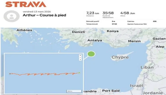
Le Monde reported on Thursday that, on March 13, the sailor was running in repetitive circles on a moving ship in the middle of the sea northwest of Cyprus. His Strava profile placed him in that area, and satellite imagery confirmed the carrier’s presence nearby at that same time.
Earlier, late February data showed the same individual running across a bridge connecting Copenhagen, Denmark, to Malmö, Sweden; at that time, the Charles de Gaulle was stationed in Malmö, as per Strava records.
French military officials responded to the reports, emphasizing that appropriate measures would be taken if verified. They also stated that navy personnel are routinely reminded of the security risks associated with using such fitness apps.
“Irregularities—if proven—do not align with current security instructions,” they noted.
History shows that sharing route data from running apps can disclose sensitive military information. In 2024, Le Monde pointed out that Macron’s bodyguards, along with those of U.S. President Joe Biden and Russian leader Vladimir Putin, had inadvertently shared location data during trips.
Furthermore, in 2018, Strava’s global heat maps exposed the whereabouts of U.S. and allied troops in Iraq, Syria, and Afghanistan. While some bases were already known, the maps also revealed routes outside military installations—potentially useful for planning attacks or ambushes.