Select Language:
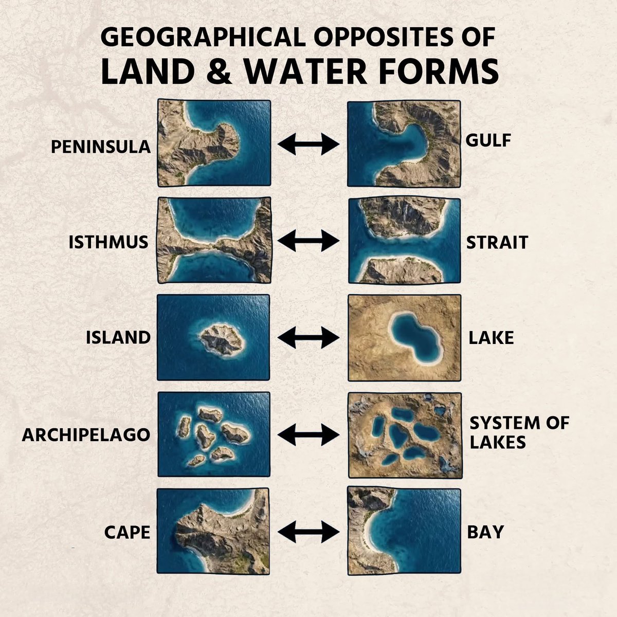
Exploring the Geographical Opposites of Land and Water Forms
1. Mountains and Valleys: The Elevation Extremes
Mountains are towering landforms rising sharply above their surroundings, usually reaching significant heights thanks to tectonic activities and geological forces. Valleys, in contrast, are the low-lying areas occurring between hills or mountains, often formed by erosion or glacial activity. While mountains symbolize grandeur and challenge, valleys evoke serenity and shelter, each playing vital roles in shaping Earth’s landscape.
Example: The Himalayas tower over the Indian subcontinent, whereas the Great Rift Valley stretches across East Africa, showcasing Earth’s diverse topography.
2. Deserts and Lakes: The Arid vs. Water-Rich Regions
Deserts are expansive areas characterized by extreme dryness, sparse vegetation, and minimal rainfall. They can be hot—like the Sahara—or cold, such as the Gobi Desert. Conversely, lakes are sizable bodies of freshwater or saltwater, serving as critical ecosystems, water sources, and recreational spots.
Contrasting Features: Deserts like the Mojave are barren and dry, while lakes like the Great Lakes of North America teem with aquatic life and support human communities.
3. Plains and Coastal Areas: The Flatlands and Shorelines
Plains are vast, flat stretches of land that extend over large areas, often suitable for agriculture and urban development. Coastal areas are regions where land meets the ocean or sea, characterized by beaches, cliffs, or wetlands. These zones are dynamic, influenced by tides, storms, and human activity.
Highlight: The Great Plains in the U.S. dominate the central part of the country, whereas the Mississippi River Delta exemplifies a thriving coastal ecosystem.
4. Plateaus and Oceans: The Elevated Flatlands and Massive Water Bodies
Plateaus are elevated flatlands often formed by volcanic activity or erosion-resistant rock layers. They provide unique habitats and sometimes serve as strategic locations for settlements. Oceans, on the other hand, are the Earth’s largest water bodies, covering about 71% of the surface and influencing global climate, weather, and ecosystems.
Insight: The Colorado Plateau in the southwestern U.S. is renowned for its striking landscapes, whereas the Pacific Ocean is the largest and deepest ocean, shaping Earth’s climate.
5. Caves and Glaciers: Subterranean and Ice Formations
Caves are natural underground hollow spaces formed through erosion, volcanic activity, or dissolving soluble rocks like limestone. They often host unique ecosystems and archaeological findings. Glaciers are massive, slow-moving ice sheets that shape mountains and valleys through erosion, marking Earth’s cold and high-altitude regions.
Significance: Carlsbad Caverns in New Mexico reveal stunning subterranean formations, while the Greenland Ice Sheet holds nearly 8% of Earth’s freshwater reserves.
6. Islands and Peninsulas: Landforms in Water
Islands are landmasses entirely surrounded by water, varying from tiny islets to large landmasses like Greenland. Peninsulas are extensions of land that jut into a body of water, connected to a larger landmass but surrounded by water on most sides.
Example: Cuba is the largest Caribbean island, whereas the Florida Peninsula extends into the Gulf of Mexico, creating a geographic boundary and access point to the Atlantic.
Final Thoughts
The Earth’s geographical features encompass contrasting land and water forms that define diverse ecosystems, climate zones, and human settlements. Understanding these oppositional natural formations enriches our appreciation of the planet’s complexity and beauty. As climate change and human activity continue to reshape these regions in 2025, awareness and preservation efforts become more crucial than ever to maintain Earth’s delicate balance.
Note: The provided image highlights the diverse spectrum of land and water features, emphasizing their interconnectedness in shaping our world.