Select Language:
The map in *Days Gone* represents a vast area of Oregon and takes some time to fully explore, making it seem smaller at first glance than it actually is. As you venture beyond the early stages, particularly past the Cascades and Hot Springs, you’ll discover that the initial region is just a fraction—around one-third—of the entire map. Progressing to new areas reveals even more territory, and it just keeps expanding.
This expansive layout can lead to feelings of confusion, with the potential to overlook significant locations or venture into less rewarding areas. To help you navigate effectively, this guide provides a comprehensive view of the full map, offering insights into the various regions of Oregon. This way, you can discover all the highlights more efficiently.
This map guide outlines the different territories within the game, the sequence in which you unlock them, and some of the dangers you may encounter in each region. Be aware that there are minor spoilers included.
Tips for Days Gone | NERO Injectors in Days Gone | IPCA Technology in Days Gone | Locations of Ambush Camps in Days Gone | Horde locations in Days Gone | How to defeat hordes in Days Gone | Skins in Days Gone | How to store weapons in Days Gone | Days Gone sound issues | Secret ending in Days Gone
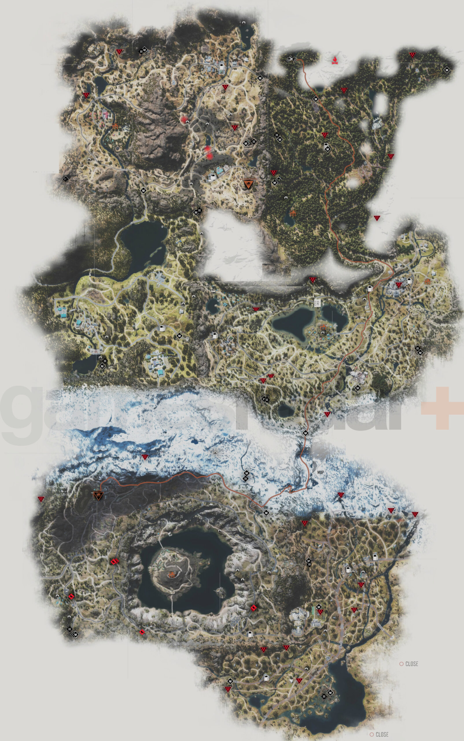
Map of Days Gone
Inside *Days Gone*, you can’t fully zoom out to see the entire map at once. The above image has been combined to give you a comprehensive view of most areas explored. The cloudy white regions indicate parts of the map that are yet to be uncovered, but many of these are mountains that are not accessible.
In the upper left corner of the map lies the desert area known as Hot Springs, featuring Ada Tucker’s camp nestled in the woods to the west. To the upper right is the Cascades, which serves as the starting point and is home to Mark Copeland’s camp in the southwest corner.
Below the Hot Springs is Iron Butte, an area heavily populated by Rippers and largely inaccessible for a significant portion of the game. Further east is Lost Lake, with Iron Mike’s camp located in the center, bordered by Lost Lake on both sides.
In the bottom third of the map, the left section is known as Crater Lake, which contains Derrick Kouri’s camp in the northwest and Colonel Garrett’s camp right in the middle of Crater Lake. Highway 97, the last region discovered to the east, has no camp at all. Finally, the expansive snowy mountainous area serves as a barrier between Crater Lake and Highway 97, aptly named Thielsen Pass.
Are you just diving into the freaker-infested world? Check out our handy video for top tips in *Days Gone*. If you’re curious about the game’s DLC, we have more information available through this link.