
Select Language:
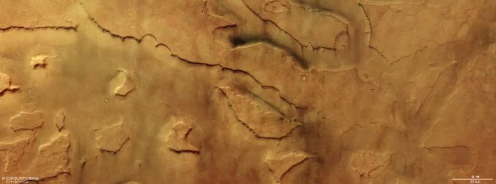
The European Space Agency (ESA) has captured stunning new images of over 30 massive dust devils swirling across an ancient canyon system on Mars. The photos reveal numerous active whirlwinds moving through Mamers Valles, a sprawling network of valleys and canyons that formed billions of years ago.
Dust devils on Mars resemble those seen in arid, dusty regions on Earth. They develop when sunlight heats the planet’s surface, causing the air immediately above to warm and start rising and spinning. As the air lifts upward, it picks up dust and forms towering columns that look like miniature tornadoes. But these Martian dust devils are anything but small—some can reach heights of up to 8 kilometers (around 5 miles), travel for many kilometers across the surface, and reach speeds of approximately 45 meters per second (roughly 160 kilometers per hour).
These swirling storms are vital for redistributing dust and influencing the planet’s atmospheric conditions. The images, captured by ESA’s Mars Express spacecraft, have been orbiting and studying Mars since 2003. Equipped with a High-Resolution Stereo Camera, the spacecraft is designed to take detailed, multi-angle images of the Martian surface. Unlike standard cameras, this instrument combines images from up to nine different channels, each viewing Mars from a slightly different angle or in various colors. When the landscape remains still during imaging, the photos align perfectly; any movement, like a dust devil, becomes clearly visible.
In the recent images, dust devils appear as small bright dots with faint trailing shadows. By analyzing these different views, scientists can determine both the direction and speed at which these storms are spinning. Prior research using data from Mars Express and ESA’s ExoMars Trace Gas Orbiter has tracked over 1,000 dust devils, deepening our understanding of Martian wind patterns.
The dust devils were observed in Mamers Valles, a vast system of valleys that extends about 1,000 kilometers across Mars. Some valleys here are as wide as 25 kilometers and as deep as 1.2 kilometers. This region transitions from the planet’s ancient southern highlands into the northern lowlands and features striking landforms, including steep-sided mesas, towering cliffs, and glaciers covered in debris. These glaciers harbor water ice beneath layers of dust and rock—an ice shell kept intact by the protective rocky cover, which prolongs its preservation despite the harsh surface conditions.
Evidence suggests that water, lava, and ice once flowed through Mamers Valles. Scientists believe glaciers gradually descended along the valley walls, eventually meeting in the middle, leaving behind ridges and patterns still visible today. This landscape dates back approximately 3.8 billion years to the late Noachian period, a time when Mars was transitioning from a warmer, wetter, and more geologically active planet into the cold, arid world observed now.
Thanks to observations from Mars Express, scientists continue to uncover new clues about this ancient, dynamic chapter in Mars’s history.
 ChatGPT
 Perplexity
 Gemini AI
 Grok AI